Hurricane Joaquin
Category 4 Atlantic hurricane in 2015
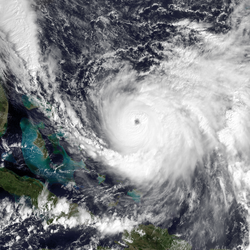 Hurricane Joaquin at peak intensity northeast of the Bahamas on October 3 | |
| Meteorological history | |
|---|---|
| Formed | September 28, 2015 |
| Extratropical | October 8, 2015 |
| Dissipated | October 15, 2015 |
| Category 4-equivalent tropical cyclone | |
| 1-minute sustained (SSHWS/NWS) | |
| Highest winds | 250 km/h (155 mph) |
Hurricane Joaquin (/hwɑːˈkiːn/ hwah-KEEN; Spanish: Huracán Joaquín [uɾaˈkaŋ xoaˈkin]) was a powerful tropical cyclone that devastated several districts of the Bahamas in early October 2015. It was the strongest Atlantic hurricane of non-tropical origin recorded in the satellite era. The tenth named storm, third hurricane, and second major hurricane of the 2015 Atlantic hurricane season, Joaquin evolved from a non-tropical low to a tropical depression on September 28, southwest of Bermuda. The depression drifted towards the southwest and became a tropical storm the next day. Joaquin then underwent rapid intensification, becoming a Category 4 major hurricane on the Saffir–Simpson scale on October 1. Meandering among the southern Bahamas, Joaquin's eye passed near or over several islands. On October 3, the hurricane weakened somewhat and began moving northeastwards. Abrupt re-intensification ensued later that day, and Joaquin acquired sustained winds of 155 mph (250 km/h), just below Category 5 strength.
Joaquin was one of the strongest hurricanes to affect the Bahamas on record. Hurricane warnings were issued for most of the Bahamas before Joaquin reached the country's southern islands. Between October 1 and 3, Joaquin caused extensive damage on Acklins, Crooked Island, Long Island, Rum Cay, and San Salvador Island. Severe storm surge inundated many communities, trapping hundreds of people in their homes; flooding persisted for days after the hurricane's departure. Prolonged, intense winds brought down trees and power lines, and unroofed homes. Relief efforts in the wake of Joaquin were hampered by heavy damage to airstrips and flooded roads. Offshore, the American cargo ship El Faro and her 33 crew members were lost to the hurricane.
Coastal flooding affected the nearby Turks and Caicos Islands, washing out roadways, compromising seawalls, and damaging homes. Strong winds and heavy rainfall caused some property damage in eastern Cuba. In Haiti, storm tides resulted in severe flooding in several departments, forcing families from their homes and destroying crops, while large waves killed a fisherman at sea. Over the Southeastern United States, a separate storm system drew tremendous moisture from the hurricane, leading to catastrophic flooding in South Carolina. A weakened Joaquin passed just west of Bermuda on October 4, bringing strong winds that caused power outages but only minor damage. Afterwards, the hurricane accelerated eastwards into colder waters, weakening further and becoming extratropical on October 8. Its remnants reached Portugal before dissipating a week later. Across its lifetime, Joaquin killed 34 people and caused US$120 million in damage.
Meteorological history
On September 25, 2015, the U.S. National Hurricane Center (NHC) began monitoring an upper-level low, accompanied by a surface trough, several hundred miles south-southwest of Bermuda, for possible tropical cyclogenesis. The system gradually consolidated as it drifted north-northwest, acquiring a closed surface low late on September 26. Convective showers and thunderstorms steadily increased on September 27, and at 00:00 UTC on September 28 the NHC assessed the system to have become a tropical depression, situated roughly 400 mi (640 km) southwest of Bermuda. Although the depression featured a well-defined low, strong wind shear displaced convection and exposed the circulation. A ridge to the north was forecast to steer the system slowly northwest into a region of higher shear; meteorologists at the NHC initially depicted the system dissipating within 96 hours based on computer model simulations. Convection developed and persisted closer to the circulation center throughout September 28, and early on September 29, Dvorak satellite classifications indicated the system became a tropical storm. Accordingly, it was assigned the name Joaquin, becoming the tenth named storm of the 2015 Atlantic hurricane season.
Strengthening of the mid-level ridge prompted a sudden shift in Joaquin's trajectory to the southwest, directing it towards the Bahamas. Forecasters at the NHC noted considerable uncertainty in the future of Joaquin, as forecast models depicted a wide range of possibilities for both track and intensity. Throughout September 29, the storm steadily intensified as its circulation became embedded within deep convection and upper-level outflow became increasingly prominent. High sea surface temperatures—around 1.1 °C (2.0 °F) above normal—and decreasing shear aided strengthening, and early on September 30, the storm achieved hurricane status. Rapid intensification ensued thereafter as an eye developed within a symmetric central dense overcast. Data from aircraft reconnaissance indicated that Joaquin reached Category 3 status on the Saffir–Simpson scale by 00:00 UTC on October 1, thereby becoming the second major hurricane of the season. Around 12:00 UTC, Joaquin passed over Samana Cay in the Bahamas with maximum sustained winds of 130 mph (215 km/h), making it a Category 4 hurricane. During this intensification phase, its eye contracted from 41 to 27 mi (66 to 43 km) in diameter. The storm's central pressure bottomed out at 931 mbar (hPa; 27.49 inHg) around 00:00 UTC on October 2, and the winds rose further to 140 mph (220 km/h).
As the ridge previously steering Joaquin southwest began retreating north, the hurricane's movement slowed and shifted west, and later north, early on October 2. This took the eyewall of Joaquin over Crooked Island and then Long Island. The slower motion of the hurricane likely caused upwelling of cooler waters beneath it, resulting in weakening despite wind shear remaining low. Reconnaissance aircraft also noted the presence of a double wind maximum, suggesting the onset of an eyewall replacement cycle—a process whereby a second, larger eye develops while the inner eye collapses. Joaquin's eye became increasingly ill-defined in satellite imagery, and the winds decreased to 125 mph (205 km/h). The hurricane made landfalls on Rum Cay and San Salvador Island on October 2 at around 16:00 UTC and 21:00 UTC, respectively; a pressure near 944 mbar (hPa; 27.88 inHg) was observed on the latter. An amplifying trough over the Southeastern United States enhanced southwesterly flow over Joaquin on October 3 and prompted the hurricane to accelerate northeast away from the Bahamas. Throughout the day the storm's eye became increasingly defined and re-intensification ensued. Aircraft reconnaissance found a considerably stronger system that afternoon: flight-level winds reached 166 mph (267 km/h) and the aircraft's stepped frequency microwave radiometer estimated surface winds of up to 159 mph (256 km/h). The NHC assessed that Joaquin became a high-end Category 4 hurricane with winds of 155 mph (250 km/h) by 12:00 UTC, making Joaquin the strongest Atlantic hurricane in the satellite era that did not form from a tropical wave or disturbance (as intense hurricanes typically do). The storm's pressure also fell to a low of 934 mbar (hPa; 27.58 inHg).
Shortly after peaking, the hurricane's overall structure began to deteriorate, signalling a weakening trend. On October 4, the storm curved towards the north-northeast between a large low-pressure system to its west and a mid-level ridge to its east. As deep convection over its core continued to wane, Joaquin passed about 70 mi (110 km) west-northwest of Bermuda near 00:00 UTC on October 5, with winds of 85 mph (140 km/h). The weakening trend paused that day as the storm's satellite presentation improved slightly, marked by brief reappearances of a distinct eye feature; this was thought to be caused by a temporary balance between higher wind shear to the north, lower wind shear to the south, and the vortex's inertial stability. Joaquin gradually turned northeastward around the periphery of the weak ridge, and subsequently accelerated toward the east-northeast as it entered the prevailing westerlies. The system maintained hurricane intensity until 15:00 UTC on October 7, by which point strengthening wind shear and an increasingly colder environment began to take their toll. The cloud pattern became lopsided as colder, drier air infiltrated the circulation, forming the first stages of a frontal structure. With its extratropical transition well underway, Joaquin lost its identity as a tropical cyclone at 00:00 UTC on October 8, roughly 445 mi (715 km) west-northwest of the northwestern Azores. During the next several days, Joaquin's extratropical remnant continued heading eastward across the Atlantic, reaching Portugal on October 12. Joaquin's remnant then slowly moved southward along the coast as it spun down, eventually dissipating over the Gulf of Cádiz on October 15.
Preparations
Tropical cyclone watches and warnings were posted throughout the Bahamas starting early on September 30 (UTC); by October 1, hurricane warnings extended from Grand Bahama Island in the northwest to Mayaguana in the southeast. As the storm moved away, the last advisories were discontinued by the morning of October 3. All schools on Exuma, Cat Island, San Salvador, and Rum Cay closed on the afternoon of October 1. Bahamasair cancelled multiple domestic flights, and most airports throughout the island nation were closed, pending post-storm runway inspections. Several cruise ships scheduled to arrive at New Providence were diverted to other ports on October 2. The nation's National Emergency Management Agency (NEMA) activated its Emergency Operations Center, and advised residents in low-lying parts of Mayaguana to evacuate. As conditions worsened, residents in southern islands of the Bahamas criticized the government for providing inadequate warning, with no emergency preparations taking place on Acklins. NEMA refuted the claim and stated people were given ample warning but many residents refused to evacuate. In some instances, police were called in to forcibly move people to shelters.
In the Turks and Caicos Islands to the southeast of the Bahamas, the storm forced the closure of schools and government offices. Two cruise ships were redirected from Grand Turk Island, and Providenciales International Airport suspended operations for a time. The islands were placed under a tropical storm warning on October 1. On October 2, tropical storm warnings were hoisted along coastal Camagüey, Las Tunas, Holguín, and Guantánamo provinces in Cuba.
From Joaquin's genesis on September 28 until October 1, several weather models indicated Joaquin could make landfall on or closely approach the East Coast of the United States. This threat prompted the governors of Maryland, New Jersey, North Carolina, South Carolina, and Virginia (including the City of Norfolk) to declare states of emergency. A mandatory evacuation order for Ocracoke Island, North Carolina, was placed at 3:00 p.m. EDT (19:00 UTC) on October 1. In New Jersey, the annual Bike MS: City to Shore Ride was canceled for the first time in its 35-year history. Joaquin eventually turned northeastwards and did not directly impact the United States.
On the afternoon of October 2, a tropical storm watch was issued for Bermuda, and a hurricane warning was in effect late on October 3. As a precaution, Royal Bermuda Regiment soldiers were placed on standby, and some emergency equipment was stationed on the east end of the Causeway to prepare for the possibility of the road becoming impassable; officials ultimately closed the Causeway late on October 4, near the height of the storm, and partially reopened it the next morning. By October 3, two cruise ships had canceled their scheduled stops to Bermuda. Most commercial flights to and from the island on October 4 were canceled, and L.F. Wade International Airport suspended all operations that afternoon. Public and private schools were scheduled to close on October 5, though one institution was prepared for use as an emergency shelter. The approaching hurricane halted ferry and bus services.
Impacts
Bahamas
Joaquin was one of the strongest known hurricanes to impact the Bahamas, as well as the strongest October hurricane to affect the country since 1866. Nearly 7,000 people there were directly affected by Joaquin's strong winds, flooding rain, and storm surge. Local newspaper The Tribune compared the effects of Joaquin to the destruction wrought by Hurricane Andrew in 1992, which struck the northwestern Bahamas as a Category 5 hurricane. Initial claims of numerous casualties throughout the island chain proved unsubstantiated, and although one man died during the storm on Long Island, his death was unrelated to the hurricane. Several weeks after the storm, officials estimated that 836 residences had been destroyed, including 413 on Long Island, 227 on San Salvador Island, 123 on Acklins, 50 on Crooked Island, and 23 on Rum Cay. Assessments by the Inter-American Development Bank (IDB) and the United Nations Economic Commission for Latin America and the Caribbean (ECLAC) estimated that Joaquin inflicted about US$120 million in damage across the Bahamian archipelago. Due to low insurance penetration, particularly in the south of the Bahamas, insured losses were pegged by the Bahamas Insurance Association at just US$14 million. About half the overall costs (US$59.8 million) were attributed to infrastructure damage, with housing contributing to another one-third (US$37.4 million).
Content from Wikipedia, available under CC BY-SA 4.0. Read on Wikipedia
Read today's article